Welcome guest. Before posting on our computer help forum, you must register. Click here it's easy and free.

Author Topic: Californai Floods Challenge Technology.  (Read 4423 times)

0 Members and 1 Guest are viewing this topic.

Geek-9pm

    Topic Starter

    Mastermind
  • Geek After Dark
  • Thanked: 1026
    • Gekk9pm bnlog
  • Certifications: List
  • Computer: Specs
  • Experience: Expert
  • OS: Windows 10
Californai Floods Challenge Technology.
« on: February 09, 2017, 05:26:42 PM »
OK. This is off topic.
You would think with all the technology that has come out of this state that the people here would have good and reliable information about important things.
Yet the experts are not able to foresee some infrastructure cross-correlated to the weather and construction practices.
Case in  point: A BIG chuck of the concrete spillway of the Oroville Earth Dam north of Sacramento blew away. Not an explosion, bet almost. The spill way was dumping a record amount of excess water from the lake and a huge part of the concrete just fell into a pit. Nobody did anything until the next day.

Why could not engineers have predicated this with computer simulations? It came as a surprise. Not cracks, no rumbles. Nothing. But there is no immediate damage. But the timing was very bad. Northern California Sacramento Valley is under Flood  Alert warning. .A very bad time to had any trouble with biggest earth dam in the USA.
(It is 226 meters high, and made of packed earth.)

So, I am wondering why the engineers did not know about his ahead of time?  I thought computer simulations would have predicted that sort of thing ahead of time.
What are computers for anyway?  Games?

[attachment deleted by admin to conserve space]

BC_Programmer


    Mastermind
  • Typing is no substitute for thinking.
  • Thanked: 1140
    • Yes
    • Yes
    • BC-Programming.com
  • Certifications: List
  • Computer: Specs
  • Experience: Beginner
  • OS: Windows 11
Re: Californai Floods Challenge Technology.
« Reply #1 on: February 09, 2017, 06:43:27 PM »
Simulations aren't magic, they are high level abstractions. They can be used to determine if a structure will likely withstand a certain force but it's not usually going to model detailed specifics of the construction material. For example if you build a simulation of a Copper and Iron bridge, it will tell you if the bridge will be strong enough to hold a certain number of cars or hold together with a certain wind (eg. predict whether you're trying to build another Gatling Gertie) but it's not going to tell that you're an idiot and the bridge wouldn't last more than a few years due to galvanic corrosion. You aren't going to run a simulation and have it say "failure will occur in January 20th, 2019 at 1:49PM during a powerful Winter storm." You aren't going to get that sort of granularity without a much lower-level simulation, which we simply don't have the computing power to do.

Structures fail for all sorts of reasons. Some predictable, some not. A billboard could fall over in 2008 because an overweight jogger leaned against it in 1968 and weakened one of the support beams, and then in 2007 a group of teenagers climbed on top and thought it would be fun to swing it back and forth, and then it fell over during the next storm. That's not something predictable with simulations.
I was trying to dereference Null Pointers before it was cool.

patio

  • Moderator


  • Genius
  • Maud' Dib
  • Thanked: 1769
    • Yes
  • Experience: Beginner
  • OS: Windows 7
Re: Californai Floods Challenge Technology.
« Reply #2 on: February 09, 2017, 07:59:54 PM »
On top of that an earthen dam has far more variables than say a concrete structure...
" Anyone who goes to a psychiatrist should have his head examined. "

Geek-9pm

    Topic Starter

    Mastermind
  • Geek After Dark
  • Thanked: 1026
    • Gekk9pm bnlog
  • Certifications: List
  • Computer: Specs
  • Experience: Expert
  • OS: Windows 10
Re: Californai Floods Challenge Technology.
« Reply #3 on: February 09, 2017, 09:00:58 PM »
On top of that an earthen dam has far more variables than say a concrete structure...
Yes, they have to inventory the worm population every spring.  :P

Post Script: Here are some more photos of the dam *censored*.
http://j.tinyurl.com/jglkwrg


Geek-9pm

    Topic Starter

    Mastermind
  • Geek After Dark
  • Thanked: 1026
    • Gekk9pm bnlog
  • Certifications: List
  • Computer: Specs
  • Experience: Expert
  • OS: Windows 10
Re: Californai Floods Challenge Technology.
« Reply #4 on: February 12, 2017, 07:08:59 PM »
It is Sunday Feb 12 about 6 pm.
We live at 300 feet. Oroville is about 200 feet. People in that area are leaving the city and going either north or east to high ground.

No specific details have been given as to how high the water will come.

What's of concern is the lack of ability to calculate how much the water will rise overnight. The are years of history for this watershed and somehow they did not see that the water was rising faster than expected. I think the engineers count on toes and fingers.  ::)
Image from htvapps.com


Really, there has already been a major amount of damage done to the environment. Major property damage is now very likely.
If you want to follow this, look for TV stations in the northern California area.

KGO TV     http://abc7news.com/
KCRA        http://www.kcra.com/local-news
KHSL        http://www.actionnewsnow.com/home/

The evacuation instructions were not good. There are major traffic jams of the highways.

Geek-9pm

    Topic Starter

    Mastermind
  • Geek After Dark
  • Thanked: 1026
    • Gekk9pm bnlog
  • Certifications: List
  • Computer: Specs
  • Experience: Expert
  • OS: Windows 10
Re: Californai Floods Challenge Technology.
« Reply #5 on: February 13, 2017, 11:46:01 AM »
Follow up.
My original idea for this topic was about using computer simulation to help predict possible scenarios of environmental changes. Namely, is the rain going to bring a flood. Here is a link to a screenshot of a topo map of Oroville and the Dam.

http://geek9pm.help9pm.com/CH/oroville_topo.png

Looking at the map, it is not clear why the local authorities are telling some many people to leave the area.Do they have some kind of computer simulation that says water will flow uphill?

No details about exactly where the flood basin will be. The exit roads they recommand are lower that most of the  greater Oroville are. In flowstone must run downhill?

Highway 70 leaving  Orville just under 200 feet above sea level.

So to re state my topic, Is there a computer simulation the will predict that water will flow uphill. Or that the laws  of physics change when people are afraid?

Just asking.   :)

Geek-9pm

    Topic Starter

    Mastermind
  • Geek After Dark
  • Thanked: 1026
    • Gekk9pm bnlog
  • Certifications: List
  • Computer: Specs
  • Experience: Expert
  • OS: Windows 10
Re: Californai Floods Challenge Technology.
« Reply #6 on: February 13, 2017, 05:38:14 PM »
I was able to find a web site that shows the projected fold area. However, I am disappointed that no explanation wa  given for the map they posted.

The officials say they made a decision based or consultation with others, but there are no diagrams or exact lists of what areas they say will be affected.  So they just told everybody to get out of town.

One would think that  it would be better to not have an evacuation if you do not provide the exact and reliable information people need. It is hard to believe that no computer simulation was done. Lessor reservoirs have had computer simulations relevant to flooding in California and Nevada . The was about ten years ago when Reno was flooded by water from the mountains of California.

I apologize for making this soundalike criticisms of the local officials. In other areas of Northern California computer flood simulations are  often used to help locals manage flood control.  So one would wonder if the Oroville decision was based on a real analytical study including computer projections.

The state of emergency still exists. No homes have been flooded. The river is a its normal level.  Some experts outside of the government are saying that no no wide-spread folding will come. Some news reports are starting to pick up on this. Meanwhile, it is said that about 100,000  people have left their homes.
It would seem the officials have not used computers to analyse the issue. The artwork on local TV stations only show animations of what has happened. That would suggest they do not have any real projections made by computer simulation.  IMO, the proper use of computers could help the officials make better decisions.

Put another way, any high-school mah teacher sound tell yu not to put 100,000 people onto 100 miles of narrow highway unless you had a real danger.
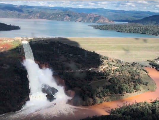
A recent photo:


Geek-9pm

    Topic Starter

    Mastermind
  • Geek After Dark
  • Thanked: 1026
    • Gekk9pm bnlog
  • Certifications: List
  • Computer: Specs
  • Experience: Expert
  • OS: Windows 10
Re: Californai Floods Challenge Technology.
« Reply #7 on: February 14, 2017, 10:08:24 AM »
When first posted, I was thinking there was some kind of error in modelling. So I wrongly thought t that there was some kind of defect in a computer model.
Wrong, Wrong and Wrong.

There is no error in any kind of simulation, calculation or estimation. The real issue was documented years ago and has nothing to do with technology at all. Not about physics. It was, as is, about biology.

The matter is clearly a political issue and I regret t that I stated this post. This sort of thing does not fit  a a forum about the use of computers and technology.

So, this topic could be closed. Or even removed. You may PM me if you want more information. In sort, the media has lied to us to promote a political agenda.  >:(